All posts by Pa

Seward

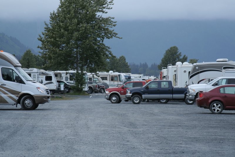
Resurrection Campground, Seward AK

Although the campground was a little tight, the more time we spent in Seward the more it grew on us. Despite being crowded, the campground was quiet and peaceful, even with everyone hanging out outside until past 11pm in the long northern twilight. Seward has a beautiful setting; it sits on the edge of a large bay surrounded on all sides by mountains capped with snowfields and glaciers . For the kids there was a great playground adjacent to the campground and a slate beach right in front of our campsite. A paved pedestrian path runs two miles along the waterfront. On every walk along the path we saw otters and/or a bald eagles. The Seward library has the fastest public wifi in 3,000 miles by an order of magnitude or two. In Whitehorse, Skagway and Haines we got dial-up speeds, at best, on the library wifi, but in Seward the connection was often as fast as our home internet back in Tucson.
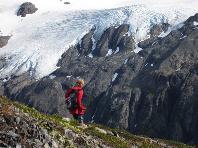
Harding Icefield Trail

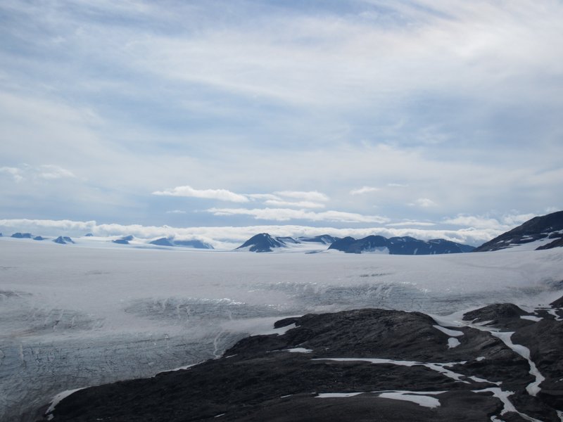
There is also some great hiking near Seward. One day Little Kid walked the entire way when the family did a two mile hike to the base of Exit Glacier in Kenai Fjords National Park. The next day Big Kid and I returned to the park and did a 9 mile (round trip) and 3,000 foot elevation gain hike up to an overlook of the Harding Icefield. The Harding Icefield is a huge (300 square miles) ice sheet left over from the last ice age that has 40 glaciers extending from its edges. The hike starts in forest near the base of Exit Glacier (so named because early explorers of the Harding Icefield used it as a way down), then climbs up through a bushy zone into alpine meadows sprinkled with flowers. Then the trail gets up into snowfields and slate scree, where we saw Dall sheep clambering on the heights above us. Big Kid really enjoyed hiking through snow in July, but my toes got a little cold in my Tevas. Finally, we crested the last rise and were looking down on the Harding Icefield, a vast expanse of snow and ice extending to the horizon with rocky mountain peaks poking through here and there. We were really lucky to have such great views of it. We met a man up there who said it was his fourth hike up the the overlook, and the first one were he could see anything besides fog and clouds.
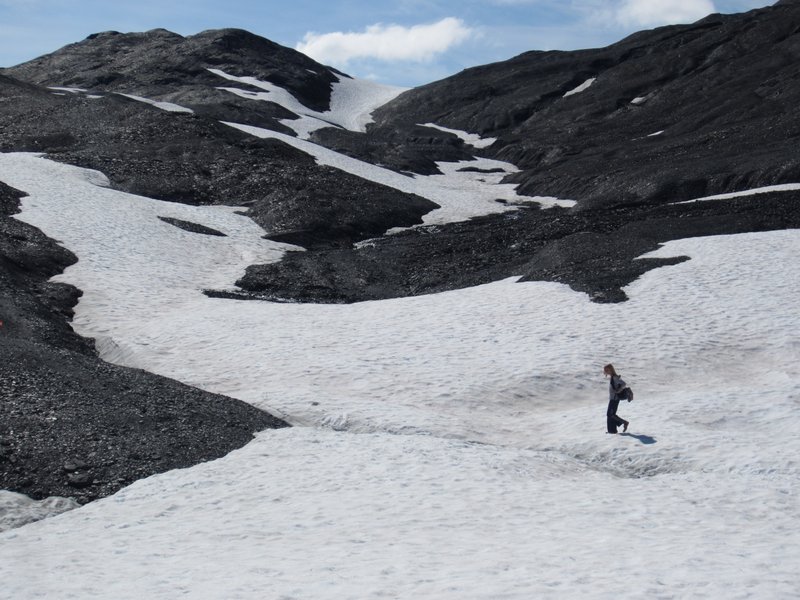
Big Kid on the upper reaches of the Harding Icefield Trail
Harding Icefield
Harding Icefield

Another day the whole family did a hike out to Tonsina Point, a beautiful spot where a creek filled with spawning salmon flows into the bay. On the way back from the point Big Kid offered to carry Little Kid. We agreed, thinking that she would give up after a few minutes (Little Kid weighs 30 lbs and Big Kid weighs only 60 lbs), but Big Kid carried her brother for 1.5 miles without any problems.

On our last full day in Seward the splurged to go to the excellent Alaska Sea Life Center. The center had large aquariums with a wife variety of Alaska sea life, from King Crabs to Stellar Sea Lions and Harbor Seals. A combined aviary and aquarium allowed us to see puffins swimming underwater, and the nests of puffins and other sea birds. There was a whole section on salmon, with aquariums with salmon at all the different stages of their life cycle. The kids, and grownups especially enjoyed a tank where you can touch sea stars, anemones and crabs.

Haines to Seward via Anchorage

I have posted anything on the blog for a couple weeks, so here is my take on where we have been since I last posted.

After spending time in Skagway and then taking the ferry (aka the Alaska Marine Highway) over to Haines and spending a few days there, we decided to make a beeline for Anchorage, 750 miles away. When we looked at the guidebooks there wasn’t a lot to see or do between Haines and Anchorage, and we were eager to get to the Kenai Peninsula, which is south of Anchorage, so it made sense to put in a few long driving days.

The first thing we did after leaving Haines was leave the United States again.  Although Haines and Skagway are both in Alaska, and they are probably only about 15 miles apart as the crow flies,  the only way to reach either of them by road, or even drive between them, is via Canada, so a few miles out of Haines we had to re-enter Canada in order to get to the rest of Alaska.

After over a week in Skagway and Haines, it was strange to be back in the emptiness of the Alaska Highway. Once again we were by ourselves on an empty two lane highway, with miles and miles of wilderness interrupted only by the occasional roadhouse (a roadhouse is a combo of a gas pump, cabins, restaurant and store). Probably 80% of the roadhouses were defunct or on the way to defunct. The first stage of roadhouse decline is the “for sale” sign, which almost all open roadhouses had. Then there are the recently closed ones that look like they closed in the last year or two, some of which still have an optimistic “for sale” sign. Next are the ones with broken windows and structural damage. Finally, there are full on ruins with collapsed buildings that are being reclaimed by the forest.

Between Haines Junction and the Alaska border we finally ran into truly bad road. This section of the highway is built on permafrost, and apparently roads built on permafrost don’t hold their flatness very well. We would be driving along on normal pavement, and then suddenly there would be a stretch of highway with humps and dips in it, like the pavement was an unmade bed or someone had put in unmarked speed bumps.  Hitting one of these wavy sections at any speed would send everything flying in the RV, so I learned to always be looking as far ahead on the road as possible, and to slow down to about 15 mph or less to navigate the rough parts.  Even with keeping a careful lookout, we had a few carnival ride experiences when we hit long slow humps that were hard to spot.

After two days of driving we finally got to the Anchorage area. After weeks weeks in the wilderness and small towns, it was like hitting the rewind button and suddenly being returned to the lower 48. Out of nowhere there were four lane highways, exit ramps, fast food restaurants, traffic lights, multiple radio stations, cell service, traffic, and big box stores.  The backcountry parts of northern Canada and Alaska are in many ways unchanged from the 1940s or 50s, so coming into Anchorage felt almost like time travel.

After a provisioning and pizza run to Costco, we spent a couple days at the pleasant Eagle River Campground a few minutes north of Anchorage. While in the Anchorage area we stumbled upon the Bear Paw Festival in Eagle River, which Big Kid really enjoyed, and spent a day walking some of the 122 miles of trails in Anchorage. The trail system took us to a playground every mile or so, so the kids had a great time with that too.

Our next stop was the Williwaw Campground in the Portage Valley, about an hour south of Anchorage. The main reason for stopping there was to visit the nearby town of Whittier. Whittier is a strange place.  It consists of a container port, a railroad station, a marina, and a few shops for tourists.  Most of the 177 residents live in a single 14 story high rise, and there is an even bigger abandoned high rise a short distance away.  The only way to reach the town by road is to go through a 2.5 mile tunnel (one of the longest tunnels in the world), and since the tunnel is one lane and shared with a railroad, cars and trucks have to wait for a 15 minute window once each hour for each direction to use the tunnel.  During World War II the US Army wanted a deep water port linked to the Alaska Railroad that was closer than Seward, so they built a railroad tunnel through the mountains at the head to Portage Valley to reach the shores of Prince William Sound, where they built a port. During the Cold War the Army built a base at the port consisting of two large high rises instead of a collection of smaller buildings. They closed the base in 1960.  One high rise became private condos and the other was abandoned, but never torn down, apparently because disposing of the debris would be too expensive.

After a couple hours walking around Whittier we hiked up to Portage Pass from the Whittier side of the tunnel. From the pass we had amazing views of Portage Glacier down below us, and even saw some chunks of glacier crash into the Portage Lake.

After a few days in Portage Valley it was time to move on to Seward. We were looking forward to Seward because the city had a number of campgrounds right in town and right on the waterfront. I guess we envisioned the typical government campground, with lots of space and vegetation between each space, because we were a little taken aback when we pulled up and saw that the campgrounds were a series big gravel lots along the waterfront with RVs packed in like sardines. However, we lucked out and managed to snag the space at the end of a row so that we had views of the bay out our windows instead of views of our neighbor eight feet away.

Whitehorse

We ended up spending a full week in Whitehorse, Yukon, because it was so darn pleasant.  Whitehorse is a neat little city with lots to see and do, and, thank goodness, not many mosquitoes. After a week of campgrounds with mosquitoes that made you want to cry, it was so nice to be able to hang out outside without being eaten alive. Also, the weather was a lot warmer and drier than we had seen for weeks. Not to mention, by staying a full week we could attend the Canada Day celebrations on July 1, and then bop down to Skagway AK for the Fourth of July; two national holidays in one week!

Whitehorse, the capital of the Yukon, has a population around 25,000 and is home to about 70% of Yukon’s total population.  It is an oasis of middle class suburban living in the middle of a vast wilderness. There’s a Starbucks, bookstore, sushi restaurants, used bookstore, big box grocery store, yoga classes in the park, paved jogging path along the river, big modern library, and playgrounds with shiny new equipment. Meanwhile, it is mostly empty wilderness for hundreds of mile around in every direction. A bald eagle swooped over me on a short hike from our campsite, and we have seen beavers in the Yukon River in town.


Cassiar Highway and the Yukon

It took us three driving days, and two layover days, to drive the 449 mile Cassiar Highway. The Cassiar ends at a junction with the Alaska Highway, just after crossing the border between British Columbia and the Yukon Territory. We are now camped in a Yukon Government campground a few kilometers outside of Whitehorse, the capital of the Yukon and the first city (pop 24,000) we have been in since Prince George BC.

The Cassiar Highway is very scenic and remote. The scenery is endless snow capped mountains interspersed with lakes and rivers. There are maybe six gas stations (with two 1970s vintage pumps each) and only one small town (Stewart/Hyder, pop 800), and that town isn’t even on the highway, it’s a 45 minute drive down a side road.  The “highway” is paved, but there are no shoulders or passing lanes, and the last portion doesn’t have a centerline, probably because that would highlight the fact that the roadway is really only 1.75 lanes wide.

Despite the primitive roadway, driving the Cassiar was pretty relaxing since we seldom saw other cars. Poking along at around 45 mph we would often go an hour or more before someone showed up in our rear view mirror, and it was frequently half an hour between oncoming vehicles.

Less relaxing was the price of gas along the Cassiar. Gas is more expensive in all of Canada; the lowest price we have paid was CAD 1.30 per liter at the Prince George Costco, which works out to around USD 4.50/gallon. The first gas station we checked on the Cassiar was CAD 1.59/liter, so we passed it by figuring the next station couldn’t be higher. Wrong. We ended up paying CAD 1.65/liter, or around USD 5.75/gal! In an RV that gets 8 MPG. Better to no think about it too much.

Fortunately, the Cassiar has three lovely BC provincial parks. We spent two nights at the beautiful Metziadan Lake Provincial Park, and then two nights at the equally stunning Boya Lake Provincial Park. Like Tyhee Lake, both campgrounds had well spaced and level campsites and friendly staff, and Boya Lake even had a playground for the kids.

 When we hit the Alaska Highway after entering the Yukon it was like returning to civilization. The Alaska Highway has shoulders and a centerline, and the gas stations are only 45 minutes apart instead of hours apart. However for every open business on the Alcan there are 2-3 closed ones, and most of the open ones were for sale.

We are now spending a few days in Whitehorse, the capital of the Yukon. More about Whitehorse later.


Banff and beyond

After spending three wintry nights in Glacier National Park we decided to have a driving day and go up to Banff National Park up in Canada, with a stop at an Old Navy in Calgary for some more warm clothes for Big Kid.

Crossing the border in the middle of nowhere Montana was quick and painless. We showed our passports, answered a few questions, and were on our way in less than five minutes.

In contrast, trying to go to the mall in Calgary in an RV with a toad (RV speak for towed vehicle) turned out to be impossible. We slowly circled the completely full parking lot, Ma navigating us over endless speed bumps, through the swarms of shoppers heading into the mall, and decided that Calgary and RVs are not a good combo.

As we approached Banff it started to rain and the temps dropped down into the low fifties; what would be considered a major winter storm in Tucson. During our day and a half in Banff we caught some glimpses of gorgeous peaks during occasional breaks in the clouds and mists, and managed to go for a pleasant stroll along the river where we were able to put the umbrellas away for part of the time. Also made a quick trip to Lake Louise, where there was a short enough break in the weather for us to see how beautiful it was. But overall Banff was a very cold and damp experience for us and with the weather supposed to stay grim for the next few days we decided to move on.

Driving north from Banff to Jasper National Park we passed through some of the most spectucular mountain scenery I have ever seen. It was mile after mile of craggy snow capped peaks, glaciers, roaring rivers, wrapped in mists and clouds. After leaving Jasper we finally escaped the clouds and cold, and when we arrived in Prince George BC it was in the low 70s and completely dry.

Our first stop in Prince George (population around 71,000) was the Costco for new tires for the toad. In our haste to depart Tucson we hadn’t really processed that the tread was getting too low for driving on wet roads. While we were there we did some provisioning before we plunged into the wilderness; the next Costco, and the next city of any size, would be Anchorage, 1,700 miles down the road.

We spent the night at a commercial campground in Prince George (our first), and then hit the road the next day for the final push to where our Alaska adventure would begin, the start of the Cassiar Highway near Kitwanga BC. All the guidebooks for driving to Alaska begin at Kitwanga for the Cassiar Highway route or Dawson’s Creek for the Alaska Highway route, and these are the places where civilization really thins out and where you get to highways that are, as the expression goes, miles and miles of miles and miles.

We stopped an hour short of the Cassiar Highway at Tyhee Lake Provincial Park. We have stayed in a lot of campgrounds over the years, and Tyhee is one of our favorites. It is located in a beautiful Aspen forest, the campsites are spaced far apart (we can’t even see any neighboring sites) and level, there are showers, and there is a great playground for the kids. The night we arrived there was a group of First Nations folks meeting for drumming and singing in the day use area, and our kids played with their kids on the playground. This morning a bald eagle flew right over the playground while the kids were playing.